![]() WHAT IS PIXIL?
WHAT IS PIXIL?
The PIXIL project is a transnational and multidisciplinary scientific and technological cooperation. Its main goal is to develop the most advanced tools to analyze the Earth's subsurface, with a special focus on fostering the uptake of geothermal energy in the region. The project will contribute to making the trans-Pyrenean area a technology hub in subsoil characterization within two years. Its success is expected to boost the wealth and creation of jobs related to the generation and management of underground natural resources in the area.
PIXIL has a strong research profile where scientific collaboration between institutions prevails. The project outcomes will result in advances in the three disciplines that make up modern geophysical imaging: Geophysics, Applied Mathematics and Computing.
![]() INTERREG V-A POCTEFA PROGRAM
INTERREG V-A POCTEFA PROGRAM
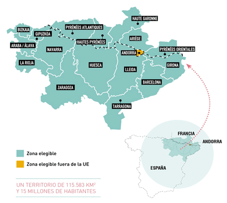
POCTEFA 2014-2020 funds activities in provinces and departments close to the French-Spanish border and the territory of Andorra.
It covers an area of 115,583 Km2 inhabited by 15 million people.
This area of cooperation involves, in particular, the following areas:
- Spain: Bizkaia, Gipuzkoa, Araba / Álava, Navarra, La Rioja, Huesca, Zaragoza, Lleida, Girona, Barcelona and Tarragona.
- France: Pyrénées-Atlantiques, Ariège, Haute-Garonne, Hautes Pyrénées, Pyrénées-Orientales
- Andorra: the whole territory
"The project has been 65% cofinanced by the European Regional Development Fund (ERDF) through the Interreg V-A Spain-France-Andorra programme (POCTEFA 2014-2020). POCTEFA aims to reinforce the economic and social integration of the French–Spanish–Andorran border. Its support is focused on developing economic, social and environmental cross-border activities through joint strategies favoring sustainable territorial development."
Link to the EU policy: ec.europa.eu/regional_policy/es/