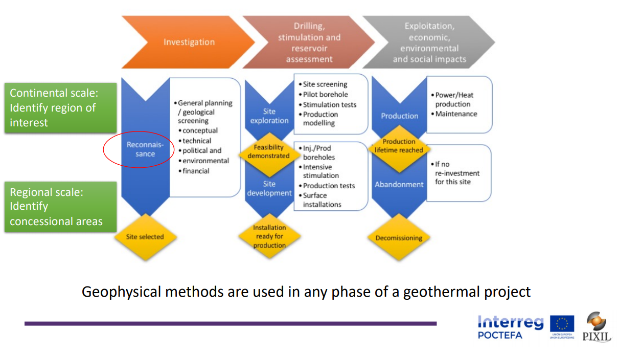
The development of geothermal projects involves several complex stages. The initial stage is crucial and consists of the investigation or exploration of geothermal anomalies and the characterisation of the geothermal reservoirs of interest. Geophysical methods, applied both at surface and in boreholes, have traditionally been indispensable in this first stage, but today they are also essential in all the other stages: drilling, stimulation, exploitation, and monitoring of environmental impact.
The application of geophysical methods is a complex process by itself as it involves taking measurements in the field to determine both the physical properties of the subsurface and its changes in the case of monitoring, and their subsequent processing and interpretation. Thus, together with geological and petrophysical data, it is possible to finally obtain a static or dynamic conceptual model that allows to evaluate the potential of the reservoir and to determine its eventual optimal exploitation points.
On May 26th, 2021, in the framework of the PIXIL project workshop "From science to praxis: experiences in the use of geophysical methods for the characterisation of geothermal anomalies", different experiences in the use of geophysical methods to characterise very diverse geothermal environments in Europe (France, Spain, Italy, Belgium, Portugal and Iceland), but also in the Caribbean, the United States and Indonesia, were presented. Methodological innovations were also introduced, such as geophysical inversions integrating electromagnetic, seismic and gravity data, and the application of new approaches: stochastic and mathematical procedures such as learning algorithms and neural networks, or geostatistical geophysical inversion to estimate petrophysical properties. The set of contributions (available on the PIXIL website) can be considered as an exponent of the current situation and recent advances that are the result of a great effort of human resources and infrastructures of research centres and universities and R+D+d companies, over many years and that is not always recognised or made visible.
There is still a long way to go, many challenges to address. Several workflows still need to be optimised, more and better data types need to be integrated to fit the physical and petrophysical properties of the reservoir, and hyper-realistic models need to be built to allow prediction of the dynamic response of the system, such as the micro-seismicity associated with drilling and stimulation processes, which a major concern in geothermal projects.
But it must be recognised that geophysics has obtained and can obtain a high-resolution image of the subsurface and accurate monitoring of reservoir processes, as demonstrated by the oil and gas industry, but with economic investments that cannot be afforded in geothermal energy. It is therefore necessary to design and develop geophysical techniques in a frugal way, both in field campaigns and in processing and modelling, to make geothermal projects sustainable without affecting safety and respect for the environment. As geophysicists, we cannot be complacent, we have the responsibility to move forward in this direction to make the benefits of our applied science "real" for society. Our PIXIL project is committed to this resposibility.