The Barcelona Supercomputing Center (BSC) is working on developing and improving HPC codes to solve geophysical imaging problems, with a particular interest in favoring the growth of geothermal energy in the cross-border area between Spain and France, thereby generating regional conditions and opportunities to move towards energy transition. This research and development activity is carried out within the PIXIL (Pyrenees Imaging eXperience: an InternationaL network) project. The main objective is to produce highly differentiating and innovative knowledge in the context of geothermal energy.
Therefore, the BSC, the Basque Center for Applied Mathematics (BCAM), and the National Institute for Research in Computer Science and Automation (INRIA) are joining forces to improve HPC codes to solve geophysical imaging and inversion problems. The value of these algorithms is that they allow us to reproduce the response of different materials to external excitation in order to analyze the real responses (data) and infer models of the subsurface as correct as possible without the need for punch out. In this sense, within the PIXIL project, HPC prototypes are being developed for modeling and inversion of electromagnetic datasets (BSC-BCAM) and inversion of seismic waves (INRIA). It is worth highlighting the participation of the industrial sector, in particular of Realtimesismic (RTS) for the inversion of seismic data and Geode-solutions for the construction of non-structural tetrahedral meshes in complex geometric domains.
By joining academia and industry, it is possible to obtain a state-of-the-art, robust modeling and inversion kernels that contribute to PIXIL's goals and, consequently, improve the regional industry's competitiveness. The PIXIL consortium members will validate all HPC prototypes, and test cases with relevance to the sector will be used. These computer codes are expected to be able to solve challenging problems (in terms of physical parameters and spatial scale) and generate innovative knowledge in the cross-border geothermal energy.
 |
 |
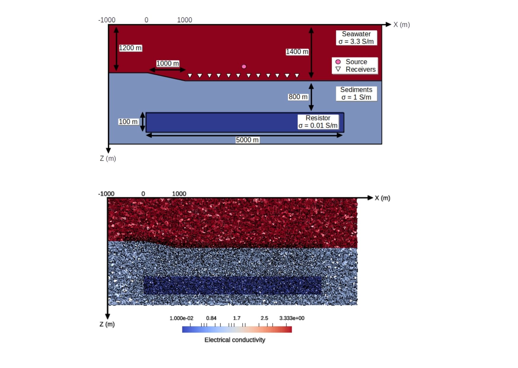
Fig. 1. 2D view of a test conductivity model (left-panel) with its resulting tetrahedral mesh (right-panel), which are used for electromagnetic modeling with the PETGEM code (http://petgem.bsc.es/) developed by the BSC.
About PIXIL
PIXIL is a cross-border and multidisciplinary scientific-technological collaboration effort, with the aim of developing the most advanced tools to analyze the earth's subsoil, with a special interest in favoring the growth of geothermal energy in the region. PIXIL has a strong research profile, where scientific collaboration between the centers prevails and whose results are advances in the three disciplines that make up modern geophysical imaging: Geophysics, Applied Mathematics and Computing.
The project has been 65% co-financed by the European Regional Development Fund (ERDF) through the Interreg VA Spain-France-Andorra Program (POCTEFA 2014-2020). The objective of POCTEFA is to reinforce the economic and social integration of the Spain-France-Andorra border area. Its assistance focuses on the development of cross-border economic, social, and environmental activities through joint strategies in favor of sustainable territorial development.