How the Eastern Valles Basin Geothermal system is helping geothermal exploration in the Pyrenees and beyond
In the current context of the transition from fossil-based to zero-carbon based energy, geothermal energy is expected to play an important role. This role can be twofold, by providing heat and/or electricity, depending on the natural conditions (high, medium, or low enthalpy geothermal reservoirs) and the necessities (small-scale or large urban supplies). Unfortunately, despite the flexibility and advancing in the different techniques to exploit this resource, geothermal energy remains underdeveloped. This is especially true for the Spanish deep geothermal sector, which is well below most European countries, although areas like the Pyrenees show a clear potential.
But, what is the bottleneck in the process of exploring, designing, implementing, and operating deep geothermal energy exploitation?
At least in Spain, the obstacles appear right at the beginning, as most exploration projects for deep geothermal energy power generation are completely paralyzed because of the difficulties of financing them. The PIXIL project aims to ease part of the initial costs, by providing new and improved tools for geophysical exploration of geothermal resources[1]. Better imaging of the subsurface means lower uncertainty, and thus a decrease in the initial investment risk.
In this global picture, La Garriga geothermal anomaly - located in the Valles basin, an urbanized area close to Barcelona - plays an important role as one of the test cases used in the PIXIL project. Controlled by the Valles fault, La Garriga geothermal anomaly is representative of most geothermal systems present in the Pyrenees. This is a well-known historically used geothermal manifestation, which now it is being studied by the University of Barcelona, in collaboration with the rest of PIXIL partners. Understanding this system will provide further information about the control mechanisms of many geothermal systems in the Pyrenees. And most importantly, it will be used as one of the setups for the testing of new geophysical tools, which may provide in the future a new window for exploring geothermal resources.
Figure caption: ERT profile (Electric Resistivity Tomography). Image showing resistivity values of a 2D cross-sectional profile perpendicular to the Valles Fault, around the Samalús area. The transition between large values (blue) and smaller values (green) of resistivity indicates the position of the Valles Fault.
[1] Arrizabalaga I., De Gregorio M., De Santiago C., García de la Noceda C., Pérez P., Urchueguía J. F. (2019). Geothermal Energy Use, Country Update for Spain. European Geothermal Congress 2019, Den Haag, The Netherlands, 11-14 June 2019

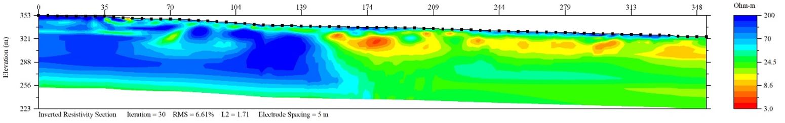
Figure caption: ERT profile (Electric Resistivity Tomography). Image showing resistivity values of a 2D cross-sectional profile perpendicular to the Valles Fault, around the Samalús area. The transition between large values (blue) and smaller values (green) of resistivity indicates the position of the Valles Fault.